| 前のトピックを表示 :: 次のトピックを表示 |
| 投稿者 |
メッセージ |
Pekari Gabor
登録日: 2016.08.24
記事: 15
|
 日時: Thu Aug 25, 2016 3:52 pm 記事の件名: Hi and a question about maps 日時: Thu Aug 25, 2016 3:52 pm 記事の件名: Hi and a question about maps |
 |
|
Hi all and SonotaCo-san
Your UFO software package is very impressive and a great help for meteor enthusiast.
Keep up the good work !
Firstly, I read the whole (english) forum, it was interesting, I learnt a lot from it.
Is there a possibility to I could add country borders to gmaps? (if it is but just manually or dot to dot isn't a problem I'm patient  ) It will be clearer to see trajectories in the busy middle europe in UFOAnalyser. ) It will be clearer to see trajectories in the busy middle europe in UFOAnalyser.
Best regards from Hungary
Gabor
|
|
| トップに戻る |
|
 |
SonotaCo
Site Admin
登録日: 2004.08.07
記事: 12671
所在地: 139.67E 35.65N
|
| 日時: Fri Aug 26, 2016 10:09 am 記事の件名: Re: Hi and a question about maps |
|
|
Hi Gabor
It seems there are two methods.
1. modify map data
To be perfectly copyright free, the ground map data for UFO series
is generated by GMAP2 (private program that I made in 2003,
which reads only NASA SRTM30 data, make reduced color map, and compress it).
I am not sure now, but probably it may be possible to modify GMAP2 to
generate maps that display additional data in special color, if I can get
copyright free numerical border data.
2.modify UA2/UO2/....
modify UA2/UO2 to be able to overlay some numerical data on the map....
2 seems more useful. It can display not only border but coast line
or additional marks .....
Anyway numerical border data that is apparently copyright free (GNU GPL is not enough) is necessary. Can you make it?
If it is possible to make original border data and publish it as copyright free data, I will consider to add new functions to my program.
The data format may be something like below, series of points.
U_MAPADD.CSV ===================
format_id, mark_id, longitude(decimal in degree), latitude(decimal in degree)
MA01, 1,+359.9999,+89.9999
MA01, 1,-0.0,-89.9999
......
P.S.
As for R90bug, I remember, there is R91format that ignore time zone of running PC. Try replacing just "R90" to "R91"
|
|
| トップに戻る |
|
|
Pekari Gabor
登録日: 2016.08.24
記事: 15
|
| 日時: Fri Aug 26, 2016 9:00 pm 記事の件名: Re: Hi and a question about maps |
|
|
Thanks for the quick answer !
| SonotaCo wrote: |
P.S.
As for R90bug, I remember, there is R91format that ignore time zone of running PC. Try replacing just "R90" to "R91" |
Works as a charm ! Thank you !
About the borderlines csv... I'm thinking about it during the weekend and will inform you as soon as possible.
|
|
| トップに戻る |
|
|
Pekari Gabor
登録日: 2016.08.24
記事: 15
|
| 日時: Mon Aug 29, 2016 3:52 pm 記事の件名: |
|
|
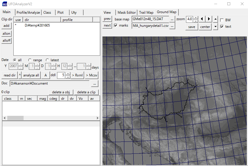
Hi SonotaCo,
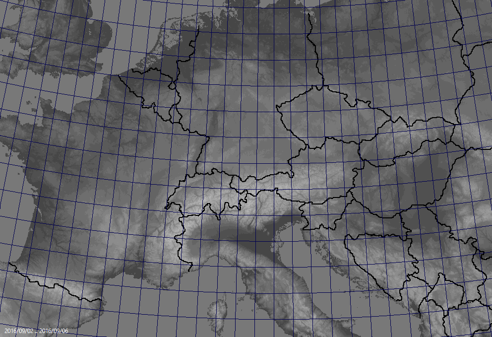
I made two maps with different quality:
MA01 - Central Europe - more than 8000 points
MA02 - Hungary detail - more than 5000 points
The MA01 was about 1 hour work, the other was less but make the whole world with MA02 details...that would be an immense work !
There is a difference between the borderlines because the result depends of the map calibrations.
| 説明: |
|

ダウンロード |
| ファイル名: |
centraleurope.csv |
| ファイルサイズ: |
237.89 KB |
| ダウンロード回数: |
409 回 |
| 説明: |
|
ダウンロード |
| ファイル名: |
hungarydetail.csv |
| ファイルサイズ: |
150.67 KB |
| ダウンロード回数: |
412 回 |
|
|
| トップに戻る |
|
|
SonotaCo
Site Admin
登録日: 2004.08.07
記事: 12671
所在地: 139.67E 35.65N
|
| 日時: Mon Aug 29, 2016 9:12 pm 記事の件名: |
|
|
Oh 
It is much earlier than I thought. You did it very rapidly.
OK, wait for (probably) a few days.
|
|
| トップに戻る |
|
|
SonotaCo
Site Admin
登録日: 2004.08.07
記事: 12671
所在地: 139.67E 35.65N
|
| 日時: Tue Aug 30, 2016 1:19 pm 記事の件名: UFOOrbitV2 V2.41 |
|
|
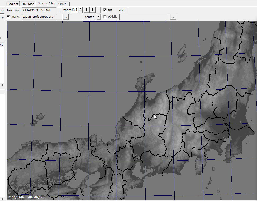
UO2 V2.41 that have additional mark overlay on GMAP was released.
http://sonotaco.com/soft/e_index.html#ufoo
currently, acceptable record ID is only MA01.
mk=1 : 1 pixel mark;
mk=2 ; 4 pixel mark;
Enjoy!
| 説明: |
| mk=1 sample using MA_hungarydetail1.csv |
|
| ファイルサイズ: |
114.4 KB |
| 閲覧数: |
15321 回 |

|
| 説明: |
| mk=2 sample using MA_centraleurope2.csv |
|
| ファイルサイズ: |
127.96 KB |
| 閲覧数: |
15321 回 |

|
| 説明: |
| mk=2 grayscale mode display |
|
| ファイルサイズ: |
28.57 KB |
| 閲覧数: |
15321 回 |

|
| 説明: |
| sample mk=1 file created by Pekari Gabor, modified by SonotaCo |
|
ダウンロード |
| ファイル名: |
MA_hungarydetail1.csv |
| ファイルサイズ: |
149.48 KB |
| ダウンロード回数: |
418 回 |
| 説明: |
| sample mk=2 file created by Pekari Gabor, modified by SonotaCo |
|
ダウンロード |
| ファイル名: |
MA_centraleurope2.csv |
| ファイルサイズ: |
234.61 KB |
| ダウンロード回数: |
422 回 |
|
|
| トップに戻る |
|
|
Pekari Gabor
登録日: 2016.08.24
記事: 15
|
| 日時: Wed Aug 31, 2016 5:44 pm 記事の件名: |
|
|
WoW
You're fantastic SonotaCo-san !
Thank you for the very quick upgrade.
|
|
| トップに戻る |
|
|
Pekari Gabor
登録日: 2016.08.24
記事: 15
|
| 日時: Sat Sep 03, 2016 9:23 pm 記事の件名: |
|
|
Dear Sonotaco-san,
Could you add this feature to UFOAnalyser too?
|
|
| トップに戻る |
|
|
SonotaCo
Site Admin
登録日: 2004.08.07
記事: 12671
所在地: 139.67E 35.65N
|
| 日時: Sun Sep 04, 2016 9:05 am 記事の件名: |
|
|
| Pekari Gabor wrote: |
Could you add this feature to UFOAnalyser too? |
Oh, I didnot think it would be requested. OK, its will not take time.
Could you explain how to make the border data?
Many international users will do it. Ex. we want a prefecture border data of Japan.
|
|
| トップに戻る |
|
|
SonotaCo
Site Admin
登録日: 2004.08.07
記事: 12671
所在地: 139.67E 35.65N
|
|
| トップに戻る |
|
|
Pekari Gabor
登録日: 2016.08.24
記事: 15
|
|
| トップに戻る |
|
|
Martin Dubs
登録日: 2014.03.04
記事: 56
|
| 日時: Mon Sep 05, 2016 11:41 pm 記事の件名: |
|
|
Hi,
many thanks for this extension. It is very useful. I added more points to the central europe border lines (with interpolation from the existing data points, too lazy to enter the points manually) to make the borders better visible at high magnification.
Martin
| 説明: |
| as centraleurope.csv, double number of points |
|
ダウンロード |
| ファイル名: |
centraleurope4.csv |
| ファイルサイズ: |
473.99 KB |
| ダウンロード回数: |
410 回 |
|
|
| トップに戻る |
|
|
SonotaCo
Site Admin
登録日: 2004.08.07
記事: 12671
所在地: 139.67E 35.65N
|
|
| トップに戻る |
|
|
Pekari Gabor
登録日: 2016.08.24
記事: 15
|
| 日時: Tue Dec 13, 2016 6:36 pm 記事の件名: |
|
|
HI Sonotaco !
There is a way to show double or triple or more observations about the same meteor in UFO-Orbit?
If I made the R91 input for it for the four different sites about the same meteor then UFOOrbit show just two of them... maybe the data quality is the best for this two, but I would like to see the other two anyway...or maybe the observation distance is bigger in that case...I don't know why UFOOrbit chose this two station but I'd like to see all of them...
I attached the R91 input files and the solution about only two stations.
Regards
Gábor
| 説明: |
|
| ファイルサイズ: |
143.59 KB |
| 閲覧数: |
14268 回 |

|
| 説明: |
|
ダウンロード |
| ファイル名: |
R91-201612102355HUAGO-HULUD.csv |
| ファイルサイズ: |
400 Bytes |
| ダウンロード回数: |
399 回 |
| 説明: |
|
ダウンロード |
| ファイル名: |
R91-201612102355HUPOL-HUMFM.csv |
| ファイルサイズ: |
393 Bytes |
| ダウンロード回数: |
391 回 |
|
|
| トップに戻る |
|
|
SonotaCo
Site Admin
登録日: 2004.08.07
記事: 12671
所在地: 139.67E 35.65N
|
| 日時: Wed Dec 14, 2016 8:01 am 記事の件名: |
|
|
Hi
This is the result of observation quality control.
You can control the quality of your results on Quality sheet of UO2.
For this case, "dD"(degree), the direction difference threshold among the direction of the pole of trajectory planes (and ...) mattered.
A trajectory plane is a plane that includes the observed trajectory and the center of the earth.
This means, the trajectory plane of HUMFM is shifted more than 5 degree from the plane that was decided by HUAGO-HULUD.
And it is more than 41 degree for the plane of HUPOL.
| 説明: |
|
| ファイルサイズ: |
71.41 KB |
| 閲覧数: |
14249 回 |

|
| 説明: |
|
| ファイルサイズ: |
74.97 KB |
| 閲覧数: |
14249 回 |

|
| 説明: |
| I recommed not to use this result but check HUPOL data |
|
| ファイルサイズ: |
76.18 KB |
| 閲覧数: |
14249 回 |

|
|
|
| トップに戻る |
|
|
|